If you haven’t used GPS navigation on your iPhone yet, it’s time to explore Apple Maps! This app is pre-installed on Apple devices and can assist you whether you’re driving, walking, biking, or using public transport. It provides details about nearby restaurants, real-time traffic updates, bus schedules, and recommendations for new places.
Apple Maps helps you plan your outings and reach your destinations safely. Whether you’re going to meet friends or pick up your grandkids, this app has everything you need. The step-by-step guide will teach you how to find and navigate to places, share your location, use Siri for directions, and customise Apple Maps to suit your preferences.
Here in this guide, we will learn
Check Our: “Apple iPad Air 2 Price in Pakistan”
Table of Contents
How to use Apple Maps as a GPS App for iPhone?
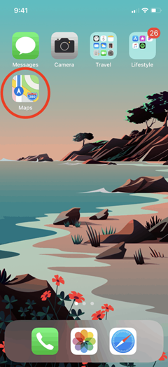
Step 1: Find Apple Maps
- Look for the Apple Maps app on your home screen. It comes pre-installed on Apple devices.

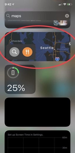
- If you can’t locate it, swipe down from the middle of your home screen to access the search bar and type “maps.”


Step 2: Open Apple Maps
- Tap on the app icon on your home screen.
- Or, swipe right from your home screen to open Apple Maps from the “today view.”

- Alternatively, clicking on an address from a website, text message, or email should automatically open Maps to that location.
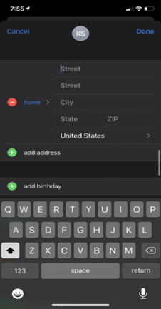
Step 3: Add Important Addresses (Favorites)
- Open the app and find the “Favorites” section.
- To add an address, tap on “Home,” “Work,” or “Add.”

- Enter the address you want to save and click “Done” in the top right corner.


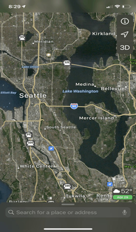
Step 4: Choose Your View: Map, Satellite, or Transit
- Tap the “i” icon in the top right corner of the screen.

- Select the view you prefer: Map, Satellite, or Transit.


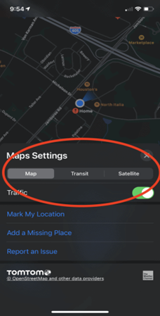

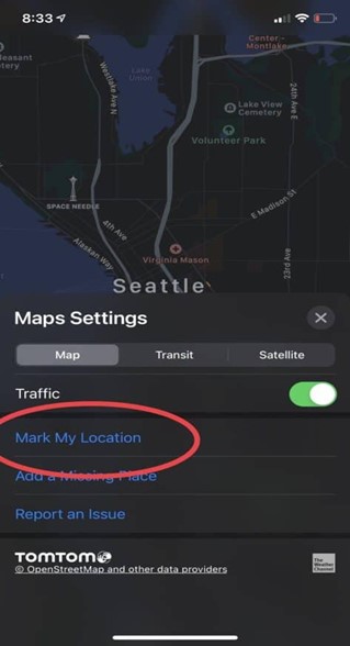
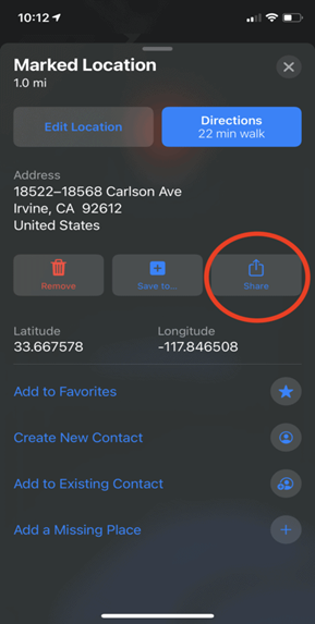
Step 5: Pin and Share Your Location
- Tap the “i” icon.
- Choose “Mark my Location” to create a red pin on the map.

- Use the “Share” icon to send your location to someone else.

- To remove a location pin, tap the red pin and select “Remove.”


By following these steps, you can make the most of Apple Maps on your iPhone for navigation and location sharing.
Check Our: “iPhone 15 Pro Max American Copy Price in Pakistan”
How to search in Apple Maps Street View?
Sure, here are the steps in simple English and vocabulary:
Step 1: Search for a Location
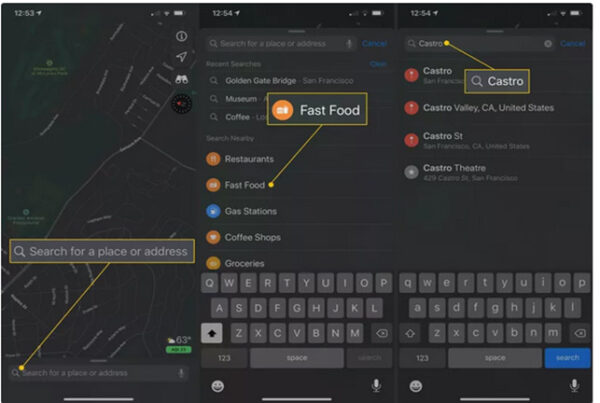
- Tap the search bar and type the name of the place you want to find.
- You can also explore categories like “Fast Food” or “Castro district” in the “Search Nearby” section.
Step 2: View the Location
- After the search, Apple Maps will show you the place on the map with a Directions icon and some photos below.
- Tap “Look Around” in the bottom left photo to get a full-screen view of the location.
Step 3: Explore the Location
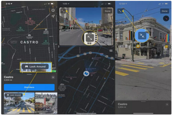
- In Look Around, you can swipe in all directions to see a close-up view of the place.
- Tap the “Expand/Unexpand” icon in the upper left to enlarge or minimise the view.
- Tap “Done” to return to the regular Maps view.
Check Our: “iPhone 14 Pro Max American Copy Price in Pakistan”
How Apple Map is the Best Navigation App for iPhone 2023?
Apple Maps had a rough start in 2012 but has improved since. It’s now a strong rival to Google Maps on iOS. It comes pre-installed and is free.
The design is attractive and user-friendly, giving turn-by-turn directions for driving, walking, and cycling. It considers real-time traffic and speed limits for accurate arrival times.
Commuters get real-time transit info with bus and train times. It has indoor maps of airports.
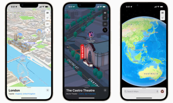
Flyover Mode and 3D city views let you explore virtually. You can add favourites and get helpful suggestions.
Updates allow sharing ETA while walking, biking, or using CarPlay with Siri. You can safely report traffic incidents using Siri or manually.
Apple Maps is free and compatible with iOS 6 and later on iPhone, iPad, and iPod touch.
Best Map App for iPhone Navigation in 2023?
GPS navigation apps for iPhones and iPads have improved a lot. They can help us find places, give us step-by-step directions, and guide us through traffic or off-road routes. Whether we’re hiking, travelling, or exploring, a map app is essential.
Some GPS apps let us download maps to save data and battery. But remember to update the offline maps regularly for accurate info.
Apart from Apple Maps, there are other good GPS apps available with different features. The following are the best cases for iPhone:.
- Google Maps
- Waze
- Citymapper
- Sygic
- TomTom Go
Google Maps
Apple has provided a pre-installed GPS app for iPhone since iOS 6, which is free and user-friendly. It offers simple turn-by-turn instructions for bikes, pedestrians, and vehicles, estimating arrival time based on speed limits and real-time traffic.
You can access real-time transportation info, and airport terminal maps, and enjoy 3D city views with Flyover Mode. It allows hands-free reporting of traffic incidents through Siri.
Pros |
Cons |
|
|
Check Our: “iPhone 14 Plus Master Copy Replica Clone Duplicate”
Waze

Waze is a Google-made navigation app with real-time traffic updates from local drivers. It helps you find the cheapest petrol along your route for cost savings. However, it requires internet access for the live map and interaction with other drivers.
Waze also allows you to share updates on construction, road hazards, and speed traps through connections with FourSquare, Twitter, or Facebook. The app’s compatibility with playing music and podcasts directly is excellent, and it works seamlessly with Apple CarPlay while driving.
Pros |
Cons |
|
|
Check Our: “Apple Mini 2 16GB 8 Inches”
Citymapper
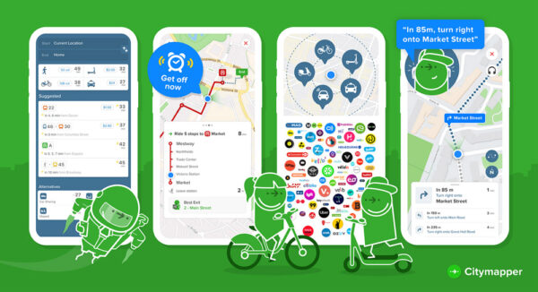
CityMapper excels at planning the quickest routes by comparing various transportation options. You can easily navigate through turn-by-turn instructions, whether walking, biking, or using public transit.
The app offers three map views, official offline maps, and no-parking zone alerts. It’s especially useful if you live in NYC or the San Francisco Bay Area. Plus, it integrates with bike and car rental apps, letting you compare taxi prices and flying maintenance scooters.
I rely on its real-time wait times and ETAs to avoid missing buses or trains during busy hours. You can track your bus or train, find the best car to board, and locate the right entrance and exit at subway or railway stations. CityMapper is your ideal travel companion.
Pros |
Cons |
|
|
Check Our: “ALCATEL 9032 Joy Tab 2 3GB 32GB Android Tablet”
Sygic

Sygic is a highly advanced GPS app for iPhone, providing a fantastic navigation experience with smart tools and impressive 3D downloadable maps. The user-friendly interface includes GPS multilingual voice guidance, making it easy to follow directions with street names.
It’s perfect for exploring cities on foot, offering regularly updated offline maps and detailed walking instructions for all points of interest. You can customise the navigation arrow.
With real-time traffic data from over 500 million users, the Dynamic Lane Assistant helps you steer clear of traffic jams, while Speed restriction alertprioritise safety.
Sygic’s Real View Navigation and Head-up Display project directions onto the windshield for nighttime driving. The app’s dashcam feature captures surrounding videos in case of collisions.
Moreover, Sygic seamlessly integrates with Apple CarPlay, displaying navigational tools on the in-dash screen. The wrong-way alert, developed in collaboration with Bosch, ensures you stay on the correct route. Overall, Sygic is a top-tier GPS app for iPhone users.
Pros |
Cons |
|
|
Check Our: “HUAWEI MEDIAPAD M5”
TomTom Go

TomTom GO offers downloadable 3D offline maps with weekly real-time traffic updates for smooth navigation. Dynamic lane assistance and easy turn-by-turn guidance ensure quick and precise directions.
The app includes speed alerts for speed cameras, and Apple CarPlay support provides top-notch in-car navigation. Its ad-free interface prioritizes effectiveness and privacy. A unique feature called “Drive to a Photo” directs you to geotagged picture locations and contacts’ addresses. You can search online for destinations and important POIs along with offline maps.
Accurate distance and timing estimates from TomTom Traffic help find alternative routes to avoid traffic jams. You can share your arrival time via messaging.
The downside is the limited 50-mile free navigation each month; further use requires a subscription.
Pros |
Cons |
|
|
Check Our: “SAMSUNG GALAXY TAB 4 8.0 2GB 16GB Tablet”
How to use iPhone Maps?
To use the iPhone Maps app and find your current location:
- Open the Maps app by tapping its icon on the Home screen. If you can’t find it on the Home screen, swipe left to access the App Library and locate it there.
- Once in the Maps app, tap the location icon in the upper-right corner. See your location on the map. Switch to 3D mode for a 3D view.
- If prompted, allow the app to access your location by tapping “Allow.”
Ending words:
In conclusion, Apple Maps is a reliable and user-friendly GPS app for iPhone, offering turn-by-turn instructions, real-time traffic updates, and easy navigation. It comes pre-installed and is a great choice for exploring places on foot or by vehicle.
You know you may get a valuable iPhone replica at your doorstep
- Value-for-money choice: Opt for a cost-effective alternative like the iPhone 12 PRO MAX Master Copy, which comes with a dependable warranty.
- Budget-friendly option: Consider the iPhone 11 Pro Max Master Copy – Replica | Clone counterpart, which offers comparable features at a more affordable price.
- Upgraded capabilities: Explore the iPhone 14 Pro Max American Copy Replica | Clone, which combines a stylish design with advanced functionalities.
- Economical selection: Look into the iPhone 13 Pro Max Master Copy Replica Clone Duplicate, known for its impressive performance and expansive display, while being budget-friendly.
- Optimal balance of affordability and functionality: Consider the iPhone 15 Pro Max American clone imitation, which strikes a harmonious blend of cost-effectiveness and feature-rich performance.